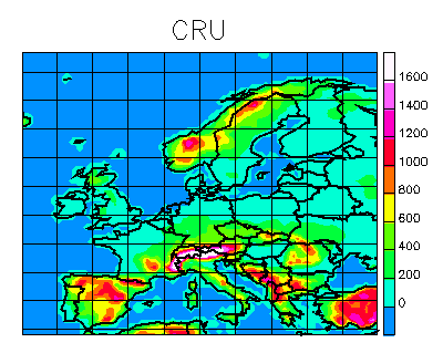
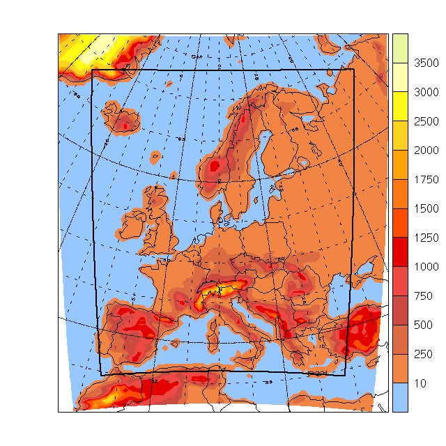
The CRU domain
The CRU domain, on which total monthly and seasonal fields from all RCM and stretched-GCM runs exist, looks like this; the lattice is 100x80, [-14.75,34.75,35.25,74.75,0,-90], i.e., a regular 0.5x0.5 degree grid. There is a netCDF file with orography and land/sea mask here.
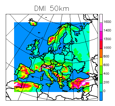
DMI
Currently, our so-called E50 domain is defined as a regular, rotated lat/lon lattice. The south pole of the rotated lattice is in actual (lon,lat)=(27,-37) degrees; in the rotated lattice, which has its 0 longitude through the actual poles, the (regular) subarea is defined by longitudes -32.65 and 15.31 and with latitudes -22.62 and 22.7; the grid distance is 0.44 degrees, making the grid size 110x104. As a shorthand for this lattice I will write [-32.65,15.31,-22.62,22.7,27,-37]. Since the boundary relaxation zone is 10 points wide, the interior area is [-28,25,10.91,-18,22,18.3,27,-37]. The integration area corresponds to the full map, the interior (or free) area corresponds to the colored part of it. We only include data for the interior part of the map.
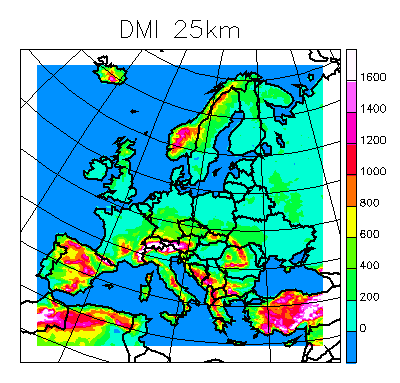
Our high-resolution area is a tiny bit smaller than the 50km area in twice the resolution. It is 174x170 in 0.22 degrees resolution, and the (interior) lattice is [-28.25,9.81,-18.22,18.96,27,-37]. The relaxation zone is 10 points.
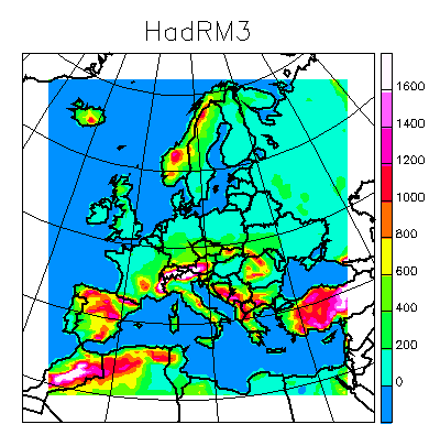
HadRM3
The area of the HadRM3P (and HadRM3H) simulations can be described as [-17.24,21.92,-21.34,20.02,10,-38] with 0.44 degrees resolution, corresponding to 90x95 points; a boundary zone of 8 points has been removed. The wind fields are on a staggered grid of 90x94 points, [-17.02,22.14,-21.12,19.8,10,-38].
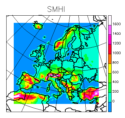
SMHI
The SMHI area is the same projection and the map [-32,14.2,-26.84,17.6,25,-32] and a lattice distance of 0.44 degrees and 90x86 interior points. This area is almost coinciding with the original DMI area; the full area is shown in the figure as the colored part.
UCM
Domain characteristics: Lambert conformal projection centered in 45N lat and 6E lon. The horizontal coordinates are cartesian. The domain is composed of a total 112x96 grids each of 50x50 km2. The integration area corresponds to the full area, and the free-area is the interior, colored part.
ETH
The current CHRM domain corresponds to the traditional EM domain used at IAC ETH for many years.
It is defined as a regular, rotated lat/lon grid with a grid spacing of 0.5 degrees, corresponding to roughly 56 km over Europe. The grid is composed of 81(x) by 91(y) points. The north pole of the rotated grid is positioned at (lon,lat)=(-170,32.5) degrees so that in geographical coordinates the domain is defined at its center as spanning longitudes 20W to 45E and latitudes 35N to 75N
The model integration area corresponds to the full map, while the nudging region is composed of the outermost 8 points, so that the interior (free) region is delimited by the rectangular box.
As part of our plans we are thinking of testing an extension of the domain to the south and to the west, probably by 10 grid points each.
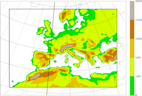
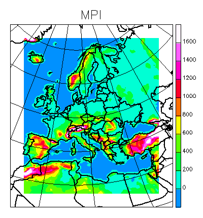
MPI
Like the HadRM3H domain the REMO domain is defined on a quasi-regular rotated lat/lon grid. The rotated north pole is at (170W, 32.5N) in usual geographical coordinates; the horizontal resolution is 0.5 degrees (~56 km). The domain consists of 97 * 109 grid points (see figure). The orography is shown only in the free-flowing area of the model domain; the eight outermost grid points are constrained by the lateral boundaries.
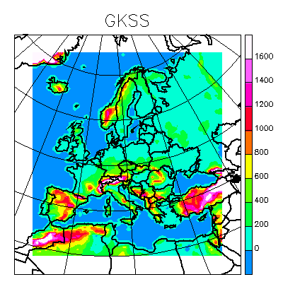
GKSS
The CLM is defined on a quasi-regular, rotated lat/lon grid. The north pole is rotated to (lon,lat)=(-170., 32.5) degrees. The horizontal resolution is 0.5 degrees (i.e. about 56 km). -NOTE the definition is not the original one! This page changed 030925. The parameters of the interior area are [-17.5,24.5,-27.5,17.5,10,-32.5]
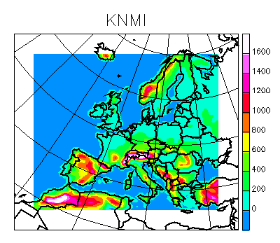
KNMI
The KNMI simulations can be described as [-32.28,8.64,-26.52,8.24,23,-28] with 0.44 degrees resolution, corresponding to 94x80 points; a boundary zone of 10 points has been removed.
met.no
The met.no area of the HIRHAM simulations can be described as [-19.5,22.5,-23.5,18.5,0,-25] with 0.5 degrees resolution, corresponding to 85x85 points, a boundary zone of 5 points has been removed (6 points at the eastern and nothern boundary). The full area is 96x96 points [-22.0,25.5,-26.0,21.5,0,-25].